This handy photo guide will help you decipher Winnipeg’s cycling infrastructure and find a route that suits your comfort level. While cyclists are allowed on all roadways, some roads have bike-specific infrastructure available.
Cycle Track / Protected Bike Lane
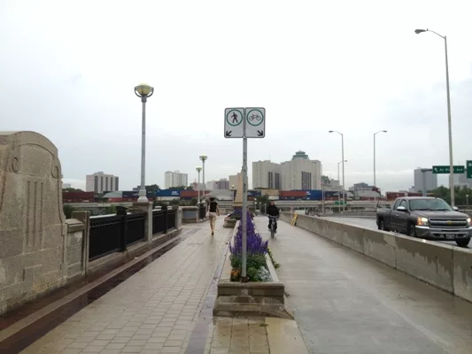
A cycle track—also referred to as a protected bike lane—is physically separated from motorized traffic lanes, parking lanes and sidewalks. This separation is created with barriers such as a rolling curb, median, bollards or parked cars. Cycle tracks / protected bike lanes can be one-way or two-way, and located on one or both sides of a street. In Winnipeg, they can also be found on bridges such as the Norwood Bridge.
(Wondering what to do when the Pembina cycle track meets a bus stop? Check it out here.)
")


Bike Boulevard
This is a road that is shared by motorists and cyclists but which is designed and intended for slower speeds and local vehicle traffic only (i.e. those who live in the neighbourhood). It discourages cut-through traffic, creating safer and more pleasant streets for all users, in particular cyclists and pedestrians. Road treatments may include curb extensions to shorten the crossing distance for pedestrians, mini traffic circles (in place of 4-way stops) to slow down all road users without requiring them to stop if no one else is in the intersection, reduced posted speeds for motorists, raised intersections, etc.

Bike Lane
Bike lanes are dedicated road space for cyclists adjacent to motorized traffic. They are separated by a painted dividing line and identified by signs and pavement markings. In Winnipeg, the pavement markings include a diamond (to indicate restricted use) and a bike stencil (to indicate it’s restricted to bicycles).

Multi-use Path
A multi-use path is shared by cyclists, pedestrians and other non-motorized users, and physically separated from motorized traffic and the roadway. Separation between cyclists and pedestrians may be presented, through the use of pavement markings, surface texture, and/or signage. Multi-use paths can be paved or crushed limestone.

Sharrow
Sharrow markings are placed on curb lanes to indicate the road is shared by motorists and cyclists. Curb lane widths vary and it cannot be assumed that the lane can be shared by a motorist and a cyclist, requiring the motorist to provide a safe distance when passing. Sharrows are indicated by painted road markings consisting of a chevron (double arrow) and a bicycle stencil along with Share the Road signage. Note: Cyclists should take special caution, as sharrows do not provide any protection beyond communicating to all road users that it is shared space.


Diamond Lane
These are curb lanes that are reserved for use by buses and cyclists. They are designated by double divided white lines, diamond patterns painted on the roadway, and signage. In Winnipeg, diamond lanes are typically in effect during peak travel times on weekdays, either in the morning or at the end of the workday.


Active Transportation Bridge / Overpass
These river crossings and overpasses are solely for the use of cyclists, pedestrians and other non-motorized users. Like multi-use paths, they are physically separated from motorized traffic.
")
")

Now you’re ready to plan your route using the infrastructure legend in the Winnipeg Cycling Map.
Definitions are adapted from “Hike it, Bike it, Like it: Your guide to active transportation facilities” produced by the City of Winnipeg, Stantec and Marr Consulting Services.